X5M
Documentation
The high precision external GNSS antenna receiver that works with your Android or iOS smartphone or tablet. The perfect solution for entry-level and field experienced professional users. Features an NTRIP correction system that receives data via Internet or Bluetooth. It has a red dot laser indicator for ease of use in geodetic surveys.
- Version: 3.0
- Main advantages:
- Uses the same GNSS L1/L2/e5 technology found in professional receivers with state-of-the-art components
- Simultaneous reception of all constellations: GPS, GLONASS, GALILEO and BEIDOU
- Multi-band NTRIP corrections with fast convergence times and robust performance, offers centimeter-level accuracy with a Fix solution in seconds
- Allows Geodetic Surveys and Photogrammetry with high-precision geotagging
- Includes its own multi-band helical GNSS antenna
- Data transfer connection via USB port and Bluetooth
- Compatible with GIS and Photogrammetry Applications that operate with NMEA data
- It has a red Laser for easy location of the points to be georeferenced on the field
- Compatibility with Android and iOS devices
- In short: Centimeter-level precision in a small, very low-power module
If you have any questions that are beyond the scope of this documentation, Please feel free to contact our Mettatec X5 Support contact.
Included components
- GNSS X5 Mobile unit
- HeliX5 multi-band GNSS antenna
- USB Type-C cable for power supply
- Adapter for mounting the device on a pole
Technical specifications
| Mechanical |
|
| Electrical |
|
| Connectivity |
|
| GNSS |
|
| Laser |

|
Ports and LEDs descriptions
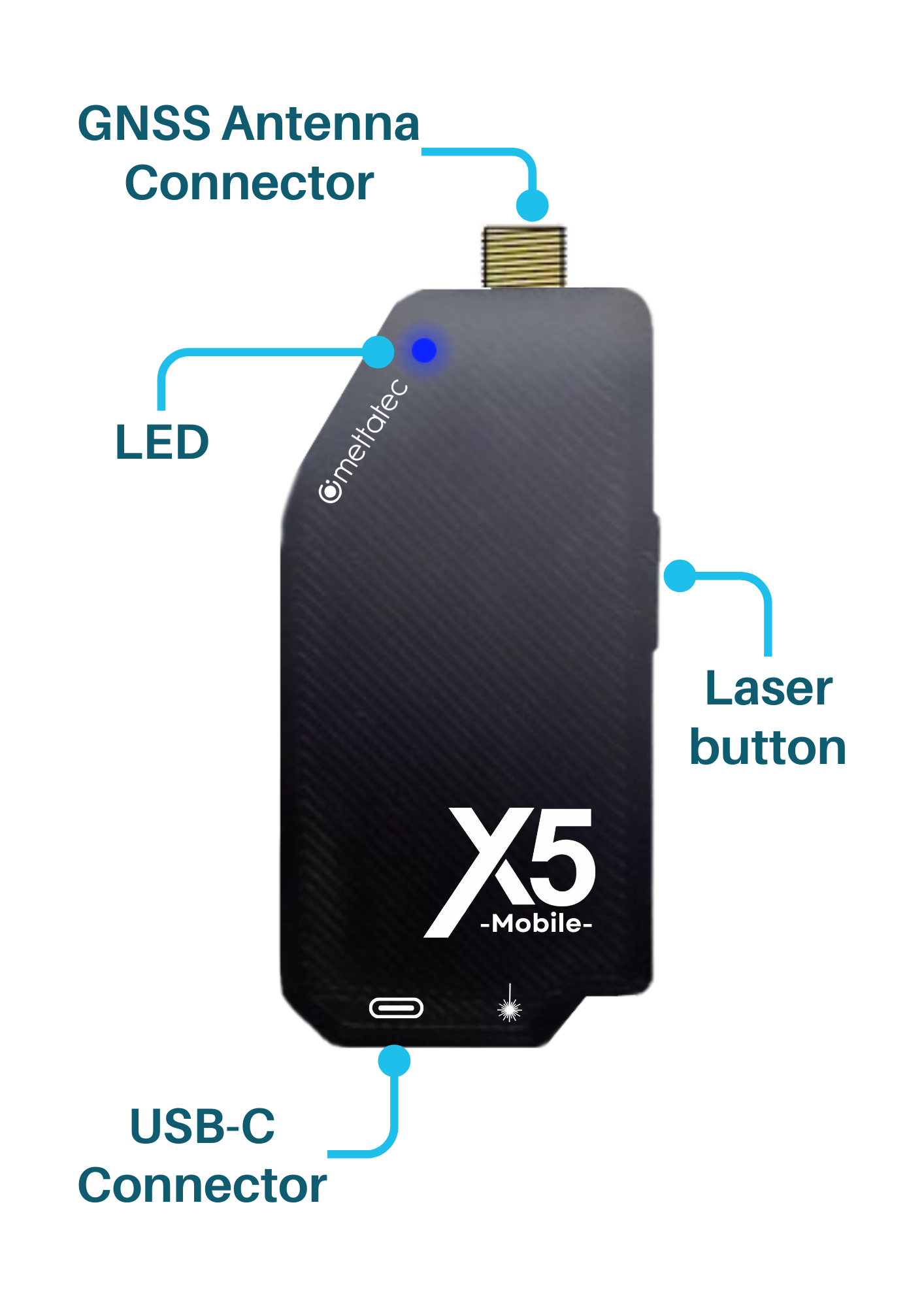
- USB-C connector: For power the module and receive data corrections
- Antenna connector: MCX female connector. Antenna included
- Button:
- Allows modifying its compatibility with Android or iOS when powering the device via USB Serial cable.
- If the button is held down when connecting the device, the compatibility will change after releasing it.
- If the button is not pressed when connecting, the previous compatibility will be maintained.
- In normal operation, push it to activate the red laser light.
- NET LED: Bluetooth indicator
- Blinking every 100 ms: Waiting for Bluetooth connection with Android compatibility
- Fading: Waiting for Bluetooth connection with iOS compatibility
- Solid: Bluetooth connected
Utilization
Installation on mobile device
To install the X5 Mobile in your device, follow the next steps:
- Paste the velcro provided in your mobile device.
- Attach the X5 Mobile.
- Connect the multi-band Helix antenna.
- Connect the USB-C cable provided to power up the X5 Mobile.
For Bluetooth mode, enter your device configuration and synchcronize with your X5 Mobile. It appears with Bluetooth ID: X5 Mobile XXXX, where XXXX is the MAC address.
Operation modes
PPK Mode
In this mode, data collected from the app is later processed to improve the position accuracy. The use of a GNSS data processing software is required. For example, in SW Maps there is an option to “Log to File” before connecting to a device, this allows to record an ubx file for post-processing.
NTRIP Mode
In this mode, the X5 Mobile receive correction data in real-time from a caster or Base connected to a caster through Internet connection with much greater range. It can be used via Serial USB or Bluetooth.
Graphic manuals
Video tutorials
Release notes
See what's new added, changed, fixed, improved or updated in the latest versions.
Version 3.0
- Added Now the position is fixed faster.
Version 2.0
- Added Compatibility with iOS devices (through Bluetooth).
- Added Now PPK mode is available.