X5S
Documentation
The X5 Standalone is a compact and advanced multi-band GNSS module adapted for integration with UAV drones. It can also be used for GNSS bases, as it has an integrated antenna that can receive RTK corrections from a nearby reference station. It offers precise navigation with centimeter-level accuracy.
- Version: 1.0
- Main advantages:
- Centimeter-level accuracy in RTK and PPK with a Fix solution in seconds.
- RTK LoRa: 10 mm accuracy, with 10 km reach at line of sight.
- NTRIP: 10 mm accuracy, receives streaming correction data from a NTRIP caster to apply as real-time corrections to a GNSS receiver.
- Could be used with external LoRa radio for RTK corrections or hot-shoe adapter for camera trigger events.
- Transmit NMEA data via UART, Bluetooth, or Wi-Fi connections.
If you have any questions that are beyond the scope of this documentation, Please feel free to contact our Mettatec X5 Support contact.
Included components
- GNSS X5 Standalone unit
- USB Type-C cable for power supply
- 32 GB MicroSD memory card
- JST-GH 6-pin cable adapter
- JST-GH 4-pin cable adapter
Technical specifications
| Mechanical |
|
|
| Electrical |
|
|
| Connectivity |
|
|
| Data |
|
|
| GNSS |
|
|
Ports description

- USB-C connector:
- USB connection for debug, powering and firmware updating
- MicroSD card slot:
- Plug-in the SD card. Maximum capacity is 64 GB.
- Antenna connector:
- MCX female connector for external antenna
- 4-pin JST connector:
- Output NMEA and RTCM3 data
- 6-pin JST connector:
- Input sensor triggers
LEDs and button description

- BLUE LED: Network indicator
- Blinking: Bluetooth waiting for connection
- Solid: Bluetooth connected
- Fading: Wi-Fi Enabled
- YELLOW LED: Fix indicator
- Off: No RTCM correction data is received
- Blinking: RTK Float is achieved
- Solid: RTK Fix is achieved
- RED LED: Logging indicator
- Blinking: SD card is not found
- Solid: Recording in SD card
- SETUP button
- Change between configuration and operative modes.
- From any operation mode, press during 2 seconds to enter configuration mode. The blue LED will blink quickly before changing mode.
- From configuration mode, press the button once to return to an operation mode.
Utilization
Configuration
The X5 Standalone generates Wi-Fi signal available under the following parameters:
- SSID: X5 Standalone XXXX, where “XXXX” represents the device's MAC address
- Password: 123456789
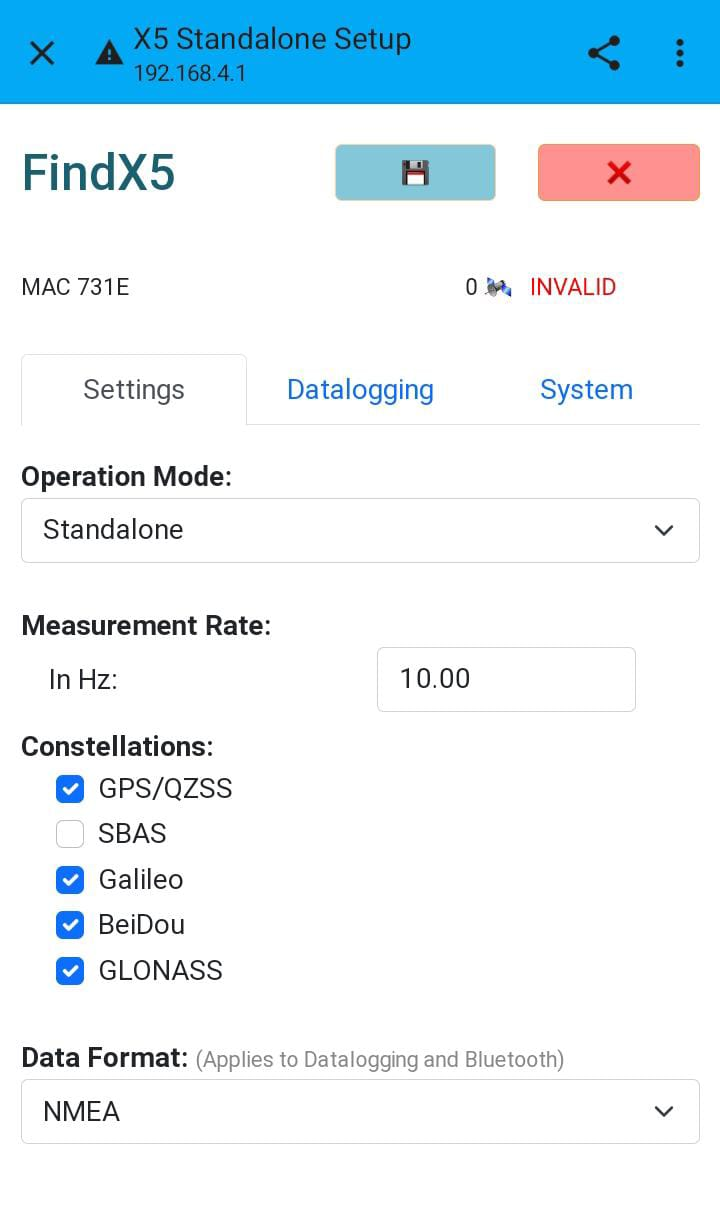
This mode is available after pressing the button for two seconds. Can be used with the FindX5 App (only Android supported) or using a web browser with the IP address http://192.168.4.1.
Connect to the Wi-Fi signal with a mobile device, here you can find three sections:
- Settings: In this section, parameters and operation modes can be changed depending on the requirements.
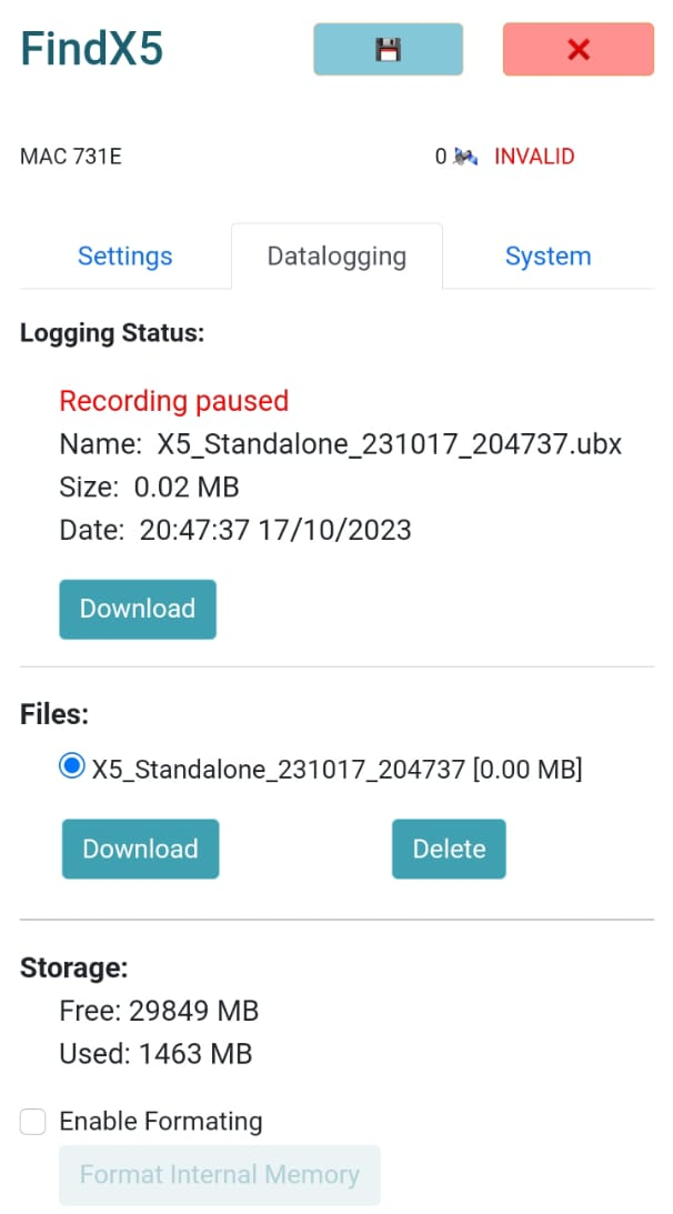
- Datalogging: Allows to view current logging file name and size, download previous UBX files and format the microSD card.
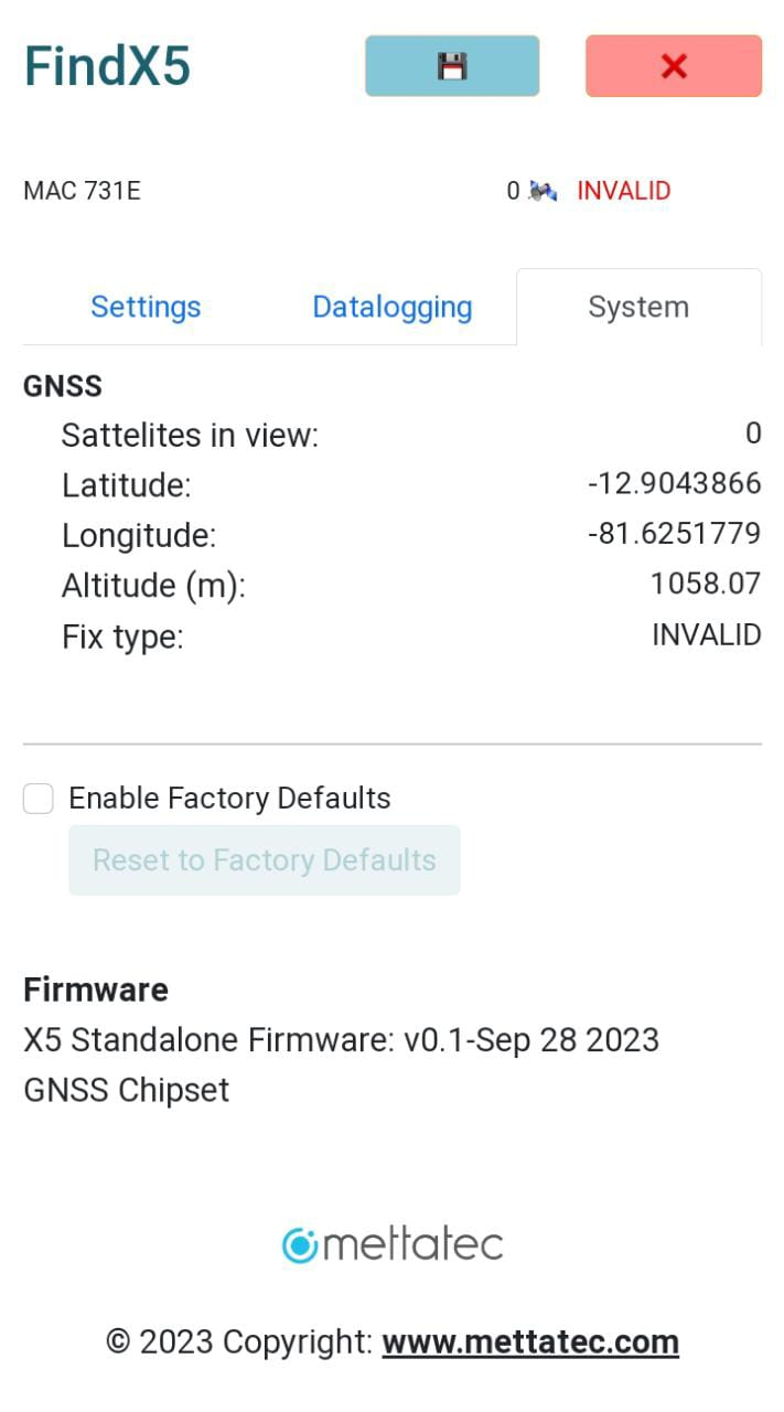
- System: Access current device GNSS information, battery status and version details. Additionally, an option is available to reset the device to its factory default settings.
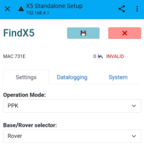
Modes of operation
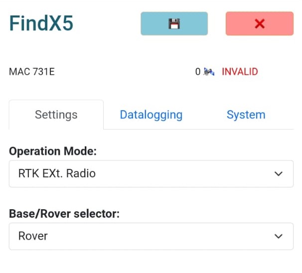
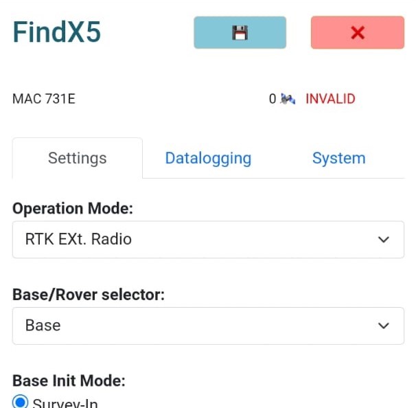
The X5S can operate in different modes, including the Configuration Mode and operating modes like a Standalone module or in PPK, RTK External radio and RTK NTRIP, each of them in Base or Rover mode.
Standalone module
In this mode, the X5 Standalone works as an independent device without receiving corrections from an external source. This mode is suitable for applications where the required accuracy is relatively low. At the end of the job, you will have .ubx files that can be further processed.
- Data format: If you need to view the information from a GIS software by connecting via Bluetooth, choose the Combinated data; otherwise, select NMEA data.
- Recommended measurement rate: 10 Hz
PPK Mode
Data collected from the module is later processed to improve the position accuracy. The use of a GNSS data processing software is required. At the end of the job, you will have .ubx files that can be further processed. It can be used in both Base and Rover mode.

The way the module defines its position can be configured as:
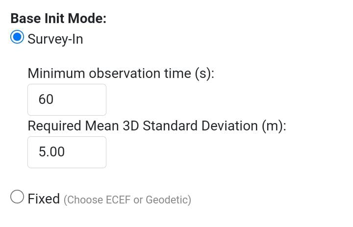
- Survey-in: Set a time limit for achieving the minimum deviation; if it is not reached within that time, the search for the minimum deviation will persist.
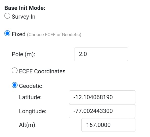
- Fixed: Define specific coordinates in ECEF or geodetic system, introduce the pole length in meters.

RTK with External radio
The module can transmit corrections in real-time to the receiver through an external Radio connected to the 4-pin JST connector. Make sure to set your radio to a baud rate of 115200 bps. You can work in Base and Rover mode:
NTRIP Mode
In this mode, the module transmits correction data in real-time to the receiver through an Internet connection with much greater range. For this mode, it is required to have Internet connection in both modules (Base and Rover). Also, a caster connection is required to use this device (contact us to receive your own Caster credentials from our web service).
For the Rover mode, the NTRIP credentials must be defined in a GIS software (like SW Maps, for example). Make sure you use the same mount point and caster information for the Base NTRIP.


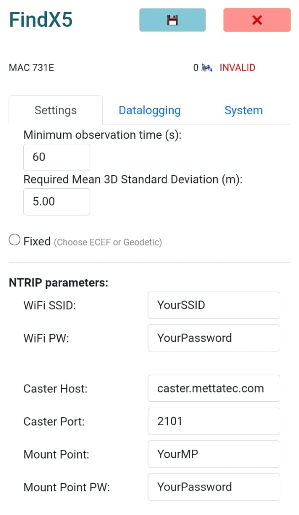
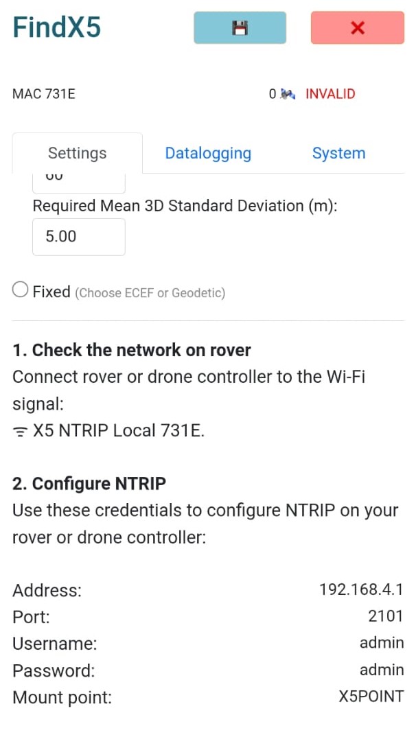
Local NTRIP Mode
In this mode, the X5S works like a base station (the way the module defines its position can be configured either as “Survey-in” or “Fixed”) transmitting correction data in real-time to a receiver through a generated local Wi-Fi signal.
This can be used with the remote controls of UAV devices with credentials from the X5S; then, it is not necessary to have an Internet connection to receive correction data.

Firmware update
Our devices are in continuous improvement and updates. Follow the next steps:
- Connect the X5 Standalone to your computer.
- Open the “X5 Updater” application.
- Browse the firmware file (*.bin) provided by Mettatec.
- Select the COM Port where the X5 Module is connected (USB-SERIAL CH340).
- Press the “Upload Firmware” button.
- The X5 Standalone will start the firmware updating process.
- When the updating is finished, the X5 Standalone will restart.
Downloads
Download the necessary firmware updates and executable applications for your device.